Abuja
Posted by OnlineNigeria.com on
About Nigeria
Constitution of the Federal Republic of Nigeria 1999
National Identity
National Security
Foreign Relations
Electoral Procedure
Ministries
States
States
Federal
Ministry of Agriculture and Water Resources
Colleges
Ministry of Commerce and Industry
Ministry of Culture, Tourism and National Orientation
Federal Ministry of Defence
Ministry of Education
Ministry of Energy
Federal Ministry of Environment
Federal Capital Territory Administration (Presidency)
Federal Ministry of Finance
Ministry of Foreign Affairs
Federal Ministry of Environment
Ministry of Health
Ministry of Information and Communications
Federal Ministry of Interior
Federal Ministry of Justice
Ministry of Labour
Mines and Steel Development
National Planning Commission (Presidency)
National Sports Commission (Presidency)
Ministry of Science and Technology
Ministry of Women Affairs
Abuja is the capital city of Nigeria. It is located in the centre of Nigeria in the Federal Capital Territory (FCT). Abuja is a planned city, which was built mainly in the 1980s and officially became Nigeria's capital on 12 December 1991, replacing the role of the previous capital Lagos. As of the 2006 census, the Federal Capital Territory has a population of 778,567.
Abuja's geography is defined by Aso Rock, a 400-metre monolith left by water erosion. The Presidential Complex, National Assembly, Supreme Court and much of the town extend to the south of the rock. "Aso" means "victorious" in the language of the (now displaced) Asokoro ("the people of victory").
Abuja is known for being the best purpose-built city in Africa as well as being one of the wealthiest and most expensive; however, the population on the semi-developed edges of the city live in shanty towns such as Karu. Karu, originally planned to house the capital's civil servants and lower income families, still has an unstable electricity supply.
History
Nigerian National Assembly, Abuja.In light of the ethnic and religious divisions of Nigeria, plans had been devised since Nigeria's independence to have its capital in a location deemed neutral to all parties. The location was eventually designated in the centre of the country in the early 1970s as it signified neutrality and national unity. Another impetus for Abuja came because of Lagos' population boom that made that city overcrowded and conditions squalid. The logic used was similar to how Brazil planned its capital Bras�lia. Construction broke ground and was dedicated in the late 1970s, but due to economic and political instability, the initial stages of the city were not complete until the late 1980s.
The master plan for Abuja and the Federal Capital Territory (FCT) was developed by International Planning Associates (IPA), a consortium made up of three American firms: Planning Research Corporation; Wallace, McHarg, Roberts and Todd; and Archisystems, a division of the Hughes Organization. The master plan for Abuja defined the general structure and major design elements of the city that are visible in the city's current form. More detailed design of the central areas of the capital, particularly its monumental core, was accomplished by Kenzo Tange, a renowned Japanese architect, along with his team of city planners at Kenzo Tange and Urtec company.
Most countries relocated their embassies to Abuja and many maintain their former embassies as consulates in Lagos, still the commercial capital of Nigeria.
Abuja is the headquarters of the Economic Community of West African States, or ECOWAS. It also has the regional headquarters of OPEC.
Abuja and the FCT have experienced huge population growth; it has been reported that some areas around Abuja have been growing at 20 to 30% per year.[3] Squatter settlements and towns have spread rapidly in and outside the city limits.[2][4] Tens of thousands of people have been evicted since former FCT Minister Nasir Ahmad el-Rufai started a demolition campaign in 2003.[5]
The Phase 1 area of the city is divided into five (5) districts. They are the Central, the Garki, Wuse, Maitama, and Asokoro. There are also five districts in Phase 2. They are Kado, Durumi, Gudu, Utako and Jabi. And the Phase 3 districts are Mabuchi, Katampe, Wuye and Gwarimpa. There are also five suburban districts, which are Nyanya, Karu, Gwagwalada, Kubwa, and Jukwoyi. Along the Airport Road are clusters of satellite settlements, namely Lugbe, Chika, Kuchigworo and Pyakassa. Other satellite settlements are Idu (the main industrial zone), Mpape, Karimu, Gwagwa, Dei-Dei (housing the International Livestock market and also International Building materials market).
Abuja International Airport
Nnamdi Azikiwe International AirportNnamdi Azikiwe International Airport (IATA: ABV, ICAO: DNAA) is the main airport serving Abuja and the surrounding capital region. It was named after Nigeria's first President, Dr. Nnamdi Azikiwe. The airport has both international and domestic terminals.
Central District Of Abuja
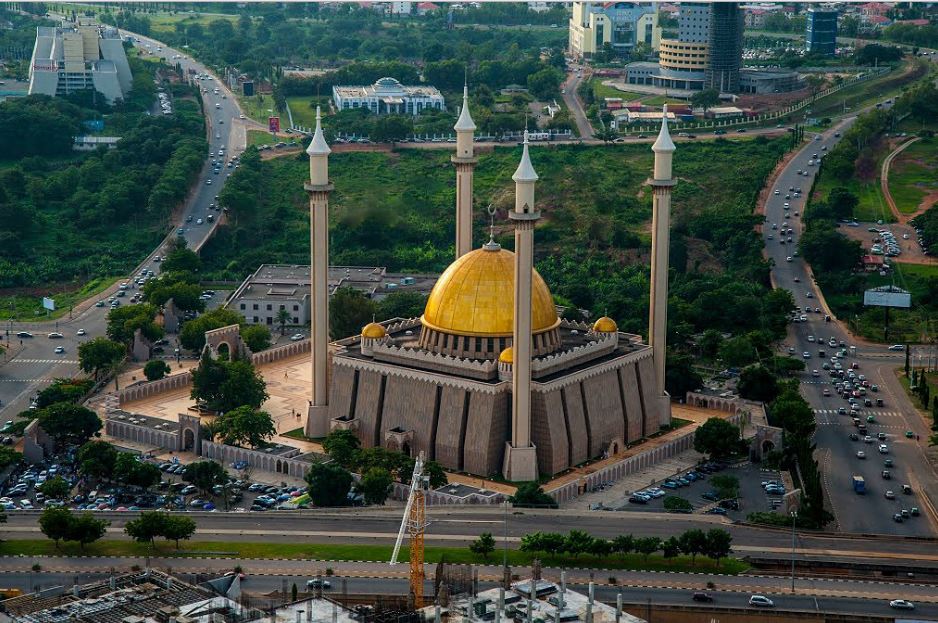
Skyline Of Abuja Central DistrictAbuja's Central District (still under construction) is located between the foot of Aso Rock and into the Three Arms Zone to the southern base of the ring road. It is like the city's spinal cord, dividing it into the northern sector with Maitama and Wuse, and the southern sector with Garki and Asokoro. While each district has its own clearly demarcated commercial and residential sectors, the Central District is the city's principal Business Zone, where practically all parastatals and multinational corporations have their offices located. An attractive area in the Central District is the region known as the Three Arms Zone, so called because it houses the administrative offices of the executive, legislative and judicial arms of the Federal Government. A few of the other sites worth seeing in the area are the Federal Secretariats alongside Shehu Shagari Way, Aso Hill, the Abuja Plant Nursery, Eagle Square (which has important historic significance,as it was in this grounds that the present democratic dispensation had its origin in May 29, 1999) and the Tomb of the Unknown Soldier across the road facing it. The National Mosque and National Church are located opposite each other on either side of Independence Avenue. A well known government office is the Ministry of Defence, popularly nicknamed "Ship House."
Garki District CBN Headquarters in AbujaThe Garki District is the area in the southwest corner of the city, having the Central District to the north and the Asokoro District to the east. The District is subdivided into units called "Areas". Garki uses a distinctive naming convention of "Area" to refer to parts of Garki. These are designated as Areas 1 to 11. Garki II is used to differentiate the area from Garki Area 2. Visitors may at first find this system of names confusing. Garki is presently the principal business district of Abuja. Numerous buildings of interest are located in this area. Some of them include the General Post Office, Abuja International Conference Center located along the busy Herbert Maculay Way, Nicon Luxury Hotel (formally known as Abuja Sofitel Hotel and Le Meridian), Agura Hotel and Old Federal Secretariat Complex Buildings (Area 1). Area 2 is mainly used for residential purposes, although a zoological garden as well as Garki Shopping Center are located in Area 2. Several banks and other commercial offices are located along Moshood Abiola Way in Area 7. The Headquarters of the Nigerian Armed Forces, namely Army Headquarters, Airforce Headquarters and Navy Headquarters are all located in the Garki District. The tallest building in this district is the Radio House, which houses the Federal Ministry of Information and Communications, and the Federal Radio Corporation of Nigeria (FRCN). The Nigerian Television Authority (NTA) Stations and Corporate Headquarters are also based in Garki. The Federal Capital Development Authority (FCDA) which oversees and runs the Administration of the Federal Capital Territory has its offices in Garki. The Office of the Minister of the Federal Capital Territory, Abuja is located in Area 10. Other places of note include the Arts and Culture Center and The Nigerian Police Mobile Force Headquarters in Area 10. The Abuja Municipal Area Council, which is the local Government administration has its headquarters in Area 10. The new United States Embassy is also located in the Garki district.
Wuse District
A typical house in Wuse District, a Suburban Area of AbujaWuse District is the northwestern part of the city, with the Maitama District to its north and the Central District to its south. The District is numbered Zones 1-8. The Wuse Market is Abuja's principal market (Zone 5). The second most important Post Office in the city is located here. This district also houses the Sheraton Hotel and Towers (Zone 4), Ibro International hotel, the Foreign Affairs Ministry Headquarters (Zone 1) and Nigerian Customs Services Headquarters, Corporate Affairs Commission (Zone 5), Federal Road Safety Commission (FRSC), National Agency For Food And Drugs Administration (NAFDAC) (Zone 7), Wuse General Hospital, and the Nigerian Tourism Development Corporation. Just as Garki District has Garki II, Wuse has Wuse II. This is distinct from Wuse Zone 2.
Maitama District
National Communications Headquarters, Abuja.Maitama District is to the north of the city, with the Wuse and Central Districts lying to its southwest and southeast respectively. This area is home to the top bracket sections of society and business, and has the reputation of being very exclusive and very expensive. Interesting buildings include the Transcorp Hilton Hotel, National Communications Commission Headquarters (NCC), National Universities Commission(NUC), Soil Conservation Complex, and Independent National Electoral Commission(INEC). The British High Commission is located along Aguiyi Ironsi Way, in Maitama. Also, the Maitama District Hospital is another notable building in Maitama. Maitama District is home to many of the European embassies in Nigeria.
Asokoro District
Abuja Residential Duplex in Asokoro District.Asokoro District, the doyen of all the districts, houses all of the state's lodges/guest houses. The ECOWAS secretariat is a focal point of interest. Asokoro is located to the east of Garki district and south of Central district. It is one of the most exclusive districts of Abuja and houses virtually all of the federal cabinet ministers; in addition, the Presidential Palace (Aso Rock) is located in Asokoro district. By virtue of this fact, Asokoro is the most secured area of the city.
Gwarimpa District
One of Abuja's smaller shopping centers.Gwarimpa is the last district located in the Abuja Municipal Area Council. It contains the largest single housing estate in Nigeria, called the Gwarimpa Housing Estate. The Estate was built by the Administration of General Sani Abacha and is the largest of its kind in Africa . It provides residence for the majority of the civil servants in Federal Ministries and government parastatals. The ECOWAS Court has an official quarters for the President and Members of the Court in Gwarimpa.
Weather and climate
The FCT experiences three weather conditions annually. This includes a warm, humid rainy season and a blistering dry season. In between the two seasons, there is a brief interlude of harmattan occasioned by the North East Trade Wind, with the main feature of dust haze, intensified coldness and dryness. The rainy season begins from April and ends in October, when daytime temperatures reach 28-30 degrees and nighttime lows hover around 22-23 degrees. In the dry season, daytime temperatures can soar as high as 40 degrees and nighttime temperatures can dip to 12 degrees, resulting in chilly evenings. Even the chilliest nights can be followed by daytime temperatures well above 30 degrees. The high altitudes and undulating terrain of the FCT act as moderating influence on the weather of the territory. Rainfall in the FCT reflects the territory's location on the windward side of the Jos Plateau and the zone of rising air masses. The annual total rainfall is in the range of 1100 mm to 1600 mm.
Vegetation
The area now designated the Federal Capital Territory falls within the Guinean forest-savanna mosaic zone of the West African sub-region. Patches of rain forest, however, occur in the Gwagwa plains, especially in the gullied train to the south and the rugged south-eastern parts of the territory. These areas of the FCT form one of the surviving occurrences of the mature forest vegetation in Nigeria.
2014 Commonwealth Games
Abuja was bidding head to head with Glasgow, Scotland to host the Commonwealth Games in 2014. If successful Abuja would have become the first African city to host the event. However, Glasgow was declared the winning city. Former Nigerian military ruler and now head of Nigeria's bid team, General Yakubu Gowon, called for all Nigerians to support the games for the "glory of Nigeria". He suggested Nigeria would be a prime location for the games because of its unity, serenity, topography and availability of standard sporting facilities. In 2003, Abuja hosted the All-Africa Games, the African regional version of the Olympics, for which it constructed an Olympic style stadium and games village. It was a more or less successful tournament with more than 7,000 athletes; however, many problems, especially logistical ones, demonstrated that Nigeria was not quite ready to host something as large as the Commonwealth Games.
Inside Abuja StadiumThe 2014 Commonwealth Games would have been an integral part of national celebration plans for Nigeria's centenary.
The Abuja bid received support from African commonwealth members as well as Australia, in what would have been the largest multi-sport event to be held thus far on the continent.
Abuja airport was planned to be modernised to cater for the capacity of the influx due to the games. This was intended to further boost their bid to host the games. A light rail transit system was also to feature in the new Abuja getting ready for the 2014 Abuja Commonwealth games. The Abuja Masterplan, a city plan including high rise buildings, artificial lakes, and tourist resorts such as Heritage city, a huge roller coaster resort, will be featured in Abuja by 2014. Few of these plans were, in the end, deemed realistic.
Abuja Skyline
The Abuja skyline is made up of mostly mid-range and a few tall buildings. Only recently have tall buildings begun to appear on the city's skyline. Most of the buildings are modern in design, reflecting that it is a new and modern city. Future plans have been made for skyscrapers, including the Millennium Tower which is currently under construction. When finished, this structure will loom above the city at 170 vertical meters.
Abuja's geography is defined by Aso Rock, a 400-metre monolith left by water erosion. The Presidential Complex, National Assembly, Supreme Court and much of the town extend to the south of the rock. "Aso" means "victorious" in the language of the (now displaced) Asokoro ("the people of victory").
Abuja is known for being the best purpose-built city in Africa as well as being one of the wealthiest and most expensive; however, the population on the semi-developed edges of the city live in shanty towns such as Karu. Karu, originally planned to house the capital's civil servants and lower income families, still has an unstable electricity supply.
History
Nigerian National Assembly, Abuja.In light of the ethnic and religious divisions of Nigeria, plans had been devised since Nigeria's independence to have its capital in a location deemed neutral to all parties. The location was eventually designated in the centre of the country in the early 1970s as it signified neutrality and national unity. Another impetus for Abuja came because of Lagos' population boom that made that city overcrowded and conditions squalid. The logic used was similar to how Brazil planned its capital Bras�lia. Construction broke ground and was dedicated in the late 1970s, but due to economic and political instability, the initial stages of the city were not complete until the late 1980s.
The master plan for Abuja and the Federal Capital Territory (FCT) was developed by International Planning Associates (IPA), a consortium made up of three American firms: Planning Research Corporation; Wallace, McHarg, Roberts and Todd; and Archisystems, a division of the Hughes Organization. The master plan for Abuja defined the general structure and major design elements of the city that are visible in the city's current form. More detailed design of the central areas of the capital, particularly its monumental core, was accomplished by Kenzo Tange, a renowned Japanese architect, along with his team of city planners at Kenzo Tange and Urtec company.
Most countries relocated their embassies to Abuja and many maintain their former embassies as consulates in Lagos, still the commercial capital of Nigeria.
Abuja is the headquarters of the Economic Community of West African States, or ECOWAS. It also has the regional headquarters of OPEC.
Abuja and the FCT have experienced huge population growth; it has been reported that some areas around Abuja have been growing at 20 to 30% per year.[3] Squatter settlements and towns have spread rapidly in and outside the city limits.[2][4] Tens of thousands of people have been evicted since former FCT Minister Nasir Ahmad el-Rufai started a demolition campaign in 2003.[5]
The Phase 1 area of the city is divided into five (5) districts. They are the Central, the Garki, Wuse, Maitama, and Asokoro. There are also five districts in Phase 2. They are Kado, Durumi, Gudu, Utako and Jabi. And the Phase 3 districts are Mabuchi, Katampe, Wuye and Gwarimpa. There are also five suburban districts, which are Nyanya, Karu, Gwagwalada, Kubwa, and Jukwoyi. Along the Airport Road are clusters of satellite settlements, namely Lugbe, Chika, Kuchigworo and Pyakassa. Other satellite settlements are Idu (the main industrial zone), Mpape, Karimu, Gwagwa, Dei-Dei (housing the International Livestock market and also International Building materials market).
Abuja International Airport
Nnamdi Azikiwe International AirportNnamdi Azikiwe International Airport (IATA: ABV, ICAO: DNAA) is the main airport serving Abuja and the surrounding capital region. It was named after Nigeria's first President, Dr. Nnamdi Azikiwe. The airport has both international and domestic terminals.
Central District Of Abuja
Skyline Of Abuja Central DistrictAbuja's Central District (still under construction) is located between the foot of Aso Rock and into the Three Arms Zone to the southern base of the ring road. It is like the city's spinal cord, dividing it into the northern sector with Maitama and Wuse, and the southern sector with Garki and Asokoro. While each district has its own clearly demarcated commercial and residential sectors, the Central District is the city's principal Business Zone, where practically all parastatals and multinational corporations have their offices located. An attractive area in the Central District is the region known as the Three Arms Zone, so called because it houses the administrative offices of the executive, legislative and judicial arms of the Federal Government. A few of the other sites worth seeing in the area are the Federal Secretariats alongside Shehu Shagari Way, Aso Hill, the Abuja Plant Nursery, Eagle Square (which has important historic significance,as it was in this grounds that the present democratic dispensation had its origin in May 29, 1999) and the Tomb of the Unknown Soldier across the road facing it. The National Mosque and National Church are located opposite each other on either side of Independence Avenue. A well known government office is the Ministry of Defence, popularly nicknamed "Ship House."
Garki District CBN Headquarters in AbujaThe Garki District is the area in the southwest corner of the city, having the Central District to the north and the Asokoro District to the east. The District is subdivided into units called "Areas". Garki uses a distinctive naming convention of "Area" to refer to parts of Garki. These are designated as Areas 1 to 11. Garki II is used to differentiate the area from Garki Area 2. Visitors may at first find this system of names confusing. Garki is presently the principal business district of Abuja. Numerous buildings of interest are located in this area. Some of them include the General Post Office, Abuja International Conference Center located along the busy Herbert Maculay Way, Nicon Luxury Hotel (formally known as Abuja Sofitel Hotel and Le Meridian), Agura Hotel and Old Federal Secretariat Complex Buildings (Area 1). Area 2 is mainly used for residential purposes, although a zoological garden as well as Garki Shopping Center are located in Area 2. Several banks and other commercial offices are located along Moshood Abiola Way in Area 7. The Headquarters of the Nigerian Armed Forces, namely Army Headquarters, Airforce Headquarters and Navy Headquarters are all located in the Garki District. The tallest building in this district is the Radio House, which houses the Federal Ministry of Information and Communications, and the Federal Radio Corporation of Nigeria (FRCN). The Nigerian Television Authority (NTA) Stations and Corporate Headquarters are also based in Garki. The Federal Capital Development Authority (FCDA) which oversees and runs the Administration of the Federal Capital Territory has its offices in Garki. The Office of the Minister of the Federal Capital Territory, Abuja is located in Area 10. Other places of note include the Arts and Culture Center and The Nigerian Police Mobile Force Headquarters in Area 10. The Abuja Municipal Area Council, which is the local Government administration has its headquarters in Area 10. The new United States Embassy is also located in the Garki district.
Wuse District
A typical house in Wuse District, a Suburban Area of AbujaWuse District is the northwestern part of the city, with the Maitama District to its north and the Central District to its south. The District is numbered Zones 1-8. The Wuse Market is Abuja's principal market (Zone 5). The second most important Post Office in the city is located here. This district also houses the Sheraton Hotel and Towers (Zone 4), Ibro International hotel, the Foreign Affairs Ministry Headquarters (Zone 1) and Nigerian Customs Services Headquarters, Corporate Affairs Commission (Zone 5), Federal Road Safety Commission (FRSC), National Agency For Food And Drugs Administration (NAFDAC) (Zone 7), Wuse General Hospital, and the Nigerian Tourism Development Corporation. Just as Garki District has Garki II, Wuse has Wuse II. This is distinct from Wuse Zone 2.
Maitama District
National Communications Headquarters, Abuja.Maitama District is to the north of the city, with the Wuse and Central Districts lying to its southwest and southeast respectively. This area is home to the top bracket sections of society and business, and has the reputation of being very exclusive and very expensive. Interesting buildings include the Transcorp Hilton Hotel, National Communications Commission Headquarters (NCC), National Universities Commission(NUC), Soil Conservation Complex, and Independent National Electoral Commission(INEC). The British High Commission is located along Aguiyi Ironsi Way, in Maitama. Also, the Maitama District Hospital is another notable building in Maitama. Maitama District is home to many of the European embassies in Nigeria.
Asokoro District
Abuja Residential Duplex in Asokoro District.Asokoro District, the doyen of all the districts, houses all of the state's lodges/guest houses. The ECOWAS secretariat is a focal point of interest. Asokoro is located to the east of Garki district and south of Central district. It is one of the most exclusive districts of Abuja and houses virtually all of the federal cabinet ministers; in addition, the Presidential Palace (Aso Rock) is located in Asokoro district. By virtue of this fact, Asokoro is the most secured area of the city.
Gwarimpa District
One of Abuja's smaller shopping centers.Gwarimpa is the last district located in the Abuja Municipal Area Council. It contains the largest single housing estate in Nigeria, called the Gwarimpa Housing Estate. The Estate was built by the Administration of General Sani Abacha and is the largest of its kind in Africa . It provides residence for the majority of the civil servants in Federal Ministries and government parastatals. The ECOWAS Court has an official quarters for the President and Members of the Court in Gwarimpa.
Weather and climate
The FCT experiences three weather conditions annually. This includes a warm, humid rainy season and a blistering dry season. In between the two seasons, there is a brief interlude of harmattan occasioned by the North East Trade Wind, with the main feature of dust haze, intensified coldness and dryness. The rainy season begins from April and ends in October, when daytime temperatures reach 28-30 degrees and nighttime lows hover around 22-23 degrees. In the dry season, daytime temperatures can soar as high as 40 degrees and nighttime temperatures can dip to 12 degrees, resulting in chilly evenings. Even the chilliest nights can be followed by daytime temperatures well above 30 degrees. The high altitudes and undulating terrain of the FCT act as moderating influence on the weather of the territory. Rainfall in the FCT reflects the territory's location on the windward side of the Jos Plateau and the zone of rising air masses. The annual total rainfall is in the range of 1100 mm to 1600 mm.
Vegetation
The area now designated the Federal Capital Territory falls within the Guinean forest-savanna mosaic zone of the West African sub-region. Patches of rain forest, however, occur in the Gwagwa plains, especially in the gullied train to the south and the rugged south-eastern parts of the territory. These areas of the FCT form one of the surviving occurrences of the mature forest vegetation in Nigeria.
2014 Commonwealth Games
Abuja was bidding head to head with Glasgow, Scotland to host the Commonwealth Games in 2014. If successful Abuja would have become the first African city to host the event. However, Glasgow was declared the winning city. Former Nigerian military ruler and now head of Nigeria's bid team, General Yakubu Gowon, called for all Nigerians to support the games for the "glory of Nigeria". He suggested Nigeria would be a prime location for the games because of its unity, serenity, topography and availability of standard sporting facilities. In 2003, Abuja hosted the All-Africa Games, the African regional version of the Olympics, for which it constructed an Olympic style stadium and games village. It was a more or less successful tournament with more than 7,000 athletes; however, many problems, especially logistical ones, demonstrated that Nigeria was not quite ready to host something as large as the Commonwealth Games.
Inside Abuja StadiumThe 2014 Commonwealth Games would have been an integral part of national celebration plans for Nigeria's centenary.
The Abuja bid received support from African commonwealth members as well as Australia, in what would have been the largest multi-sport event to be held thus far on the continent.
Abuja airport was planned to be modernised to cater for the capacity of the influx due to the games. This was intended to further boost their bid to host the games. A light rail transit system was also to feature in the new Abuja getting ready for the 2014 Abuja Commonwealth games. The Abuja Masterplan, a city plan including high rise buildings, artificial lakes, and tourist resorts such as Heritage city, a huge roller coaster resort, will be featured in Abuja by 2014. Few of these plans were, in the end, deemed realistic.
Abuja Skyline
The Abuja skyline is made up of mostly mid-range and a few tall buildings. Only recently have tall buildings begun to appear on the city's skyline. Most of the buildings are modern in design, reflecting that it is a new and modern city. Future plans have been made for skyscrapers, including the Millennium Tower which is currently under construction. When finished, this structure will loom above the city at 170 vertical meters.
